
Titanic in Charts & Maps: Visualizing the Disaster Through Data and Diagrams
📌 Explore the Titanic’s tragedy through charts, tables, graphs, and maps. See passenger survival rates, structural diagrams, lifeboat capacity, and iceberg locations—all based on historical records.
RMS Titanic: Charts, Tables, Diagrams, Graphs, and Maps 📊🗺️📜
Introduction: Visualizing the Titanic’s History
This collection of historical charts, tables, diagrams, graphs, and maps presents a comprehensive visual representation of the Titanic’s construction, voyage, disaster, and aftermath. Unlike narrative accounts, these visual tools offer data-driven insights into passenger survival rates, ship dimensions, structural weaknesses, and iceberg locations.
For teachers, students, genealogists, and historians, these materials provide an authentic, research-based approach to understanding the Titanic’s social hierarchy, engineering feats, and tragic sinking. By analyzing the raw data through charts and diagrams, students can formulate essays, reports, and discussions grounded in historical evidence rather than speculation.
Contents of This Page
RMS Titanic Images - Historical Charts, Tables, Diagrams, Graphs, Maps is a collection from many sources from the 1910s. These images present a memorable way to infuse a sense of what happened to the world's most famous tragedy!
These images focus on different stages in the life of the titanic, its survivors and victims, cemented into History.
Charts

Graphic Chart of Titanic Passengers, Survivors, and Victims, 0-12 Years of Age, from All Classes. Using Wikipedia and Titanica as Source Materials, We Extracted Passengers Younger than 13 Years Old. There Were 5 in First Class; 24 in Second Class; And 79 in Third Class. | GGA Image ID # 1be62403d9

Graphic Chart of Titanic Passengers, Survivors, and Victims, 13-17 Years of Age, from All Classes. Using Wikipedia and Titanica as Source Materials, We Extracted Passengers between 13 and 17 Years Old. There Were 8 in First Class; 10 in Second Class; And 56 in Third Class. | GGA Image ID # 1be64b1515

Graphic Chart of Titanic Passengers, Survivors, and Victims, 18-24 Years of Age, from All Classes. Using Wikipedia and Titanica as Source Materials, We Extracted Passengers between 18 and 24 Years Old. There Were 44 in First Class; 63 in Second Class; And 240 in Third Class. | GGA Image ID # 1be667ca2a

Graphic Chart of Titanic Passengers, Survivors, and Victims, 25-34 Years of Age, from All Classes. Using Wikipedia and Titanica as Source Materials, We Extracted Passengers between 25 and 34 Years Old. There Were 61 in First Class; 103 in Second Class; And 209 in Third Class. | GGA Image ID # 1be66b9abb

Graphic Chart of Titanic Passengers, Survivors, and Victims, 35-44 Years of Age, From All Classes. Using Wikipedia and Titanica as source materials, we extracted passengers between 35 and 44 years old. There were 83 in First Class; 43 in Second Class; and 86 in Third Class. | GGA Image ID # 1be69232d1

Graphic Chart of Titanic Passengers, Survivors, and Victims, 45-54 Years of Age, from All Classes. Using Wikipedia and Titanica as Source Materials, We Extracted Passengers between 45 and 54 Years Old. There Were 77 in First Class; 25 in Second Class; And 23 in Third Class. | GGA Image ID # 1be698805c

Graphic Chart of Titanic Passengers, Survivors, and Victims, 55-64 Years of Age, from All Classes. Using Wikipedia and Titanica as Source Materials, We Extracted Passengers between 55 and 64 Years Old. There Were 43 in First Class; 11 in Second Class; And 8 in Third Class. | GGA Image ID # 1be6d264c3

Graphic Chart of Titanic Passengers, Survivors, and Victims, 65+ Years of Age, from All Classes. Using Wikipedia and Titanica as Source Materials, We Extracted Passengers Who Were 65+ Years Old. There Were 5 in First Class, 2 in Second Class, and 4 in Third Class. There Were No Survivors in This Group. | GGA Image ID # 1be70b33ac
Tables
Watertight Compartments - RMS Titanic
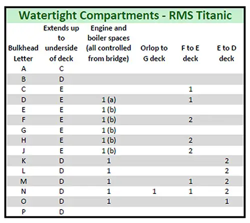
Table of the Titanic's Watertight Compartments. The Table Shows the Decks to Which the Bulkheads Extended, and the Number of Doors in Them. 1(a). There Was Another Watertight Door at the after End of the Water-Tight Passage through the Bunker Immediately Aft of D Bulkhead. This Door and the One on the D Bulkhead Formed a Double Protection to the Forward Boiler Room. 1(b). The Water-Tight Doors for These Bulkheads Were Not on Them but Were at the End of a Water-Tight Passage (About 9 Feet Long), Leading from the Bulkhead through the Bunker into the Compartment. | GGA Image ID # 104bedf904
Contents of Watertight Compartments
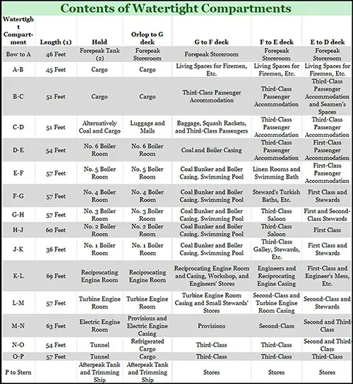
Table of the Content of Each Water-Tight Compartment on the RMS Titanic. (1) Length of Each Watertight Compartment in Fore and Aft Direction. (2) Not Used Except For Trimming Ship. The Table Shows the Actual Contents of Each Separate Watertight Compartment. The Compartments Are Shown in the Left Column, the Contents of Each Compartment Being Read Off Horizontally. The Contents of Each Watertight Compartment Are Separately Given in the Deck Space. | GGA Image ID # 104c0b7869
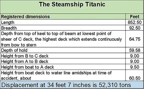
Table of Registered Dimensions of the RMS Titanic. | GGA Image ID # 104b3a8d78
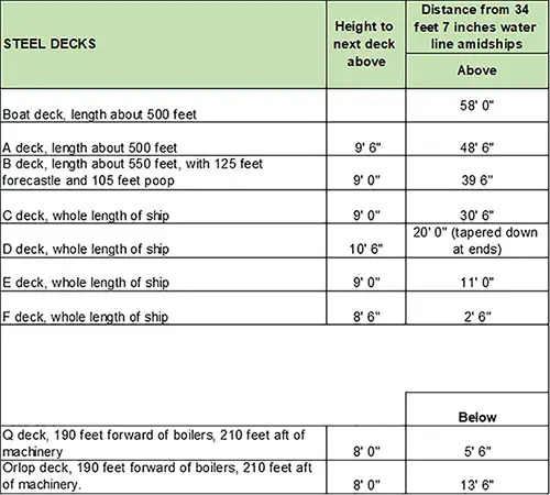
Table of Structural Arrangements of the RMS Titanic. | GGA Image ID # 104ba135a1
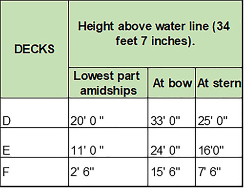
The Position of Titanic's Water-Tight Bulkheads on Decks D, E, and F in Relation to the Water Line. | GGA Image ID # 104ba69415
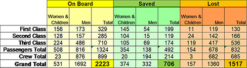
Table of RMS Titanic Passengers and Crew, Saved or Lost. © GG Archives 2019. | GGA Image ID # 105dd9c0c4
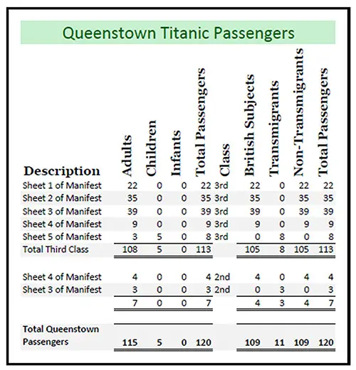
Table 1: Queenstown Outbound Recapitultation - RMS Titanic 11 April 1912. | GGA Image ID # 1027efbee7
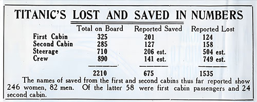
Early Tally of Titanic's Lost and Saved in Numbers. The names of saved from the first and second cabins thus far reported show 246 women, 82 men. Of the latter 58 were first cabin passengers and 24 second cabin. New York American (17 April 1912) p. 4. | GGA Image ID # 10b0da3a51
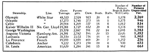
Table Showing Popular Passenger Steamships, Gross Tonnage, Passengers and Crew Capacity, Lifeboats and Rafts, Number of People Provided for and Number of People Not Provided For. There is practically not a transatlantic liner running out of New York Harbor that carries enough small boats to hold all of its passengers and crew. Many liners do not have enough lifeboat equipment for half of the ship's company legally allowed. Few have equipment sufficient to carry half of the passengers and crew. The Outlook (27 April 1912) p. 899. | GGA Image ID # 10e6ff2b3b
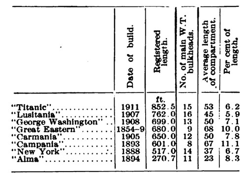
The table shows the character of the bulkhead subdivision on the Titanic, the Lusitania, the Great Eastern, the Paris, and other notable ships. In the matter of height of bulkheads above load water-line, the Great Eastern stands first, followed by the Paris, the Lusitania, and the Titanic. © Engineering Magazine. Scientific American (11 May 1912) p. 418b. | GGA Image ID # 10a5d7d63e
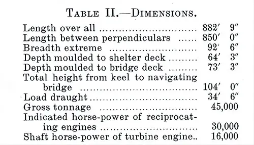
Table II: Dimensions of the Olympic and Titanic as Constructed. A comparison of the foregoing information with the table of dimensions of other vessels given in the preceding chapter will show that the Great Küstern was 170 feet shorter and 20,600 gross tons less; the Kaiser Wilhelm II and the Kronprinzessin Cecilie are each 172 feet shorter and 25,600 tons less; the Adriatic 141 feet shorter and 20,500 tons less; and the Mauretania 90 feet shorter and about 13,000 tons less. The Shipbuilder (Midsummer 1911) p. 19. | GGA Image ID # 10b4e3d3a4
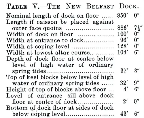
Table V: The New Belfast Graving Dock. The Olympic was docked on the 1st April, 1911, in the new graving dock belonging to the Belfast Harbor Commissioners, of which the principal dimensions are given in Table V., and which has the distinction of being the largest graving dock in the world at the present time. The Shipbuilder (Midsummer 1911) p. 43. | GGA Image ID # 10bcab60bf
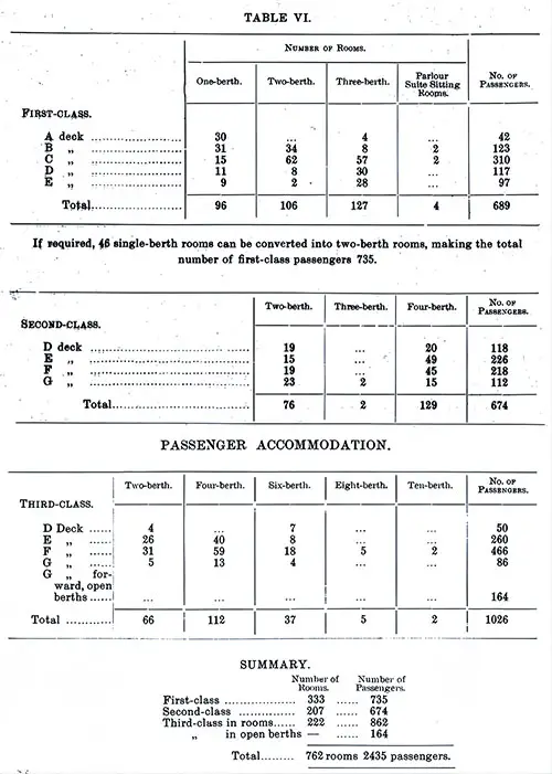
Table VI: Accommodations for First, Second, and Third Class Passengers by Class, Deck, and Configuration of Suites. The Shipbuilder (Midsummer 1911) p. 68-69. | GGA Image ID # 10c3d5d503
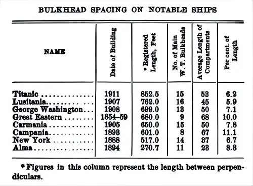
Bulkhead Spacing on Notable Ships: Titanic, Lusitania, George Washington, Great Eastern, Carmania, Campania, New York, and Alma. The Unsinkable Titanic (1912) p,. 67. | GGA Image ID # 10780b9b2e
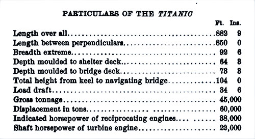
Principal Dimensions and Particulars of the RMS Titanic. The Unsinkable Titanic (1912) p,. 95. | GGA Image ID # 1079a228a2
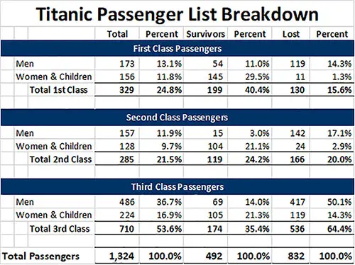
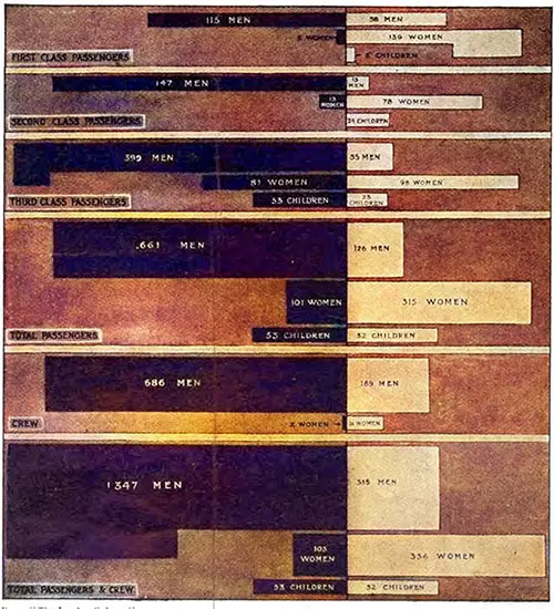
A Breakdown of Titanic Passengers by Class and Survival. | GGA Image ID # 105a45366c
Diagrams
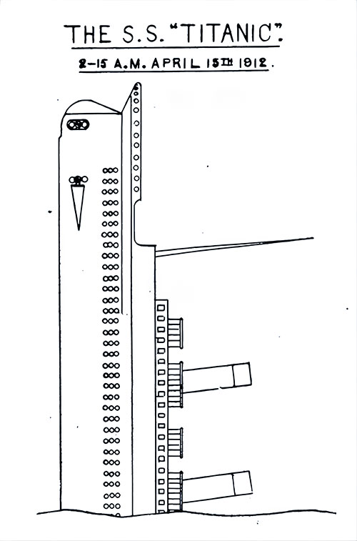
Diagram of the RMS Titanic, 2:15 am, 15 April 1912 (Frontispiece). And She Did Eventually Attain the Perpendicular. How to Save a Big Ship from Sinking (1915) p. 00. | GGA Image ID # 10a2d3d49b
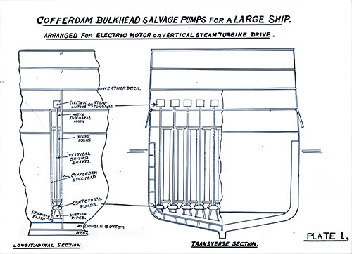
Plate 1: Diagram of the Cofferdam Bulkhead Salvage Pumps for a Large Ship. Arranged for Electric Motor or Vertical Steam Turbine Drive. Longitudinal Secion on Left; Transverse Section shown on Right. How to Save a Big Ship from Sinking (1915) p. 24. | GGA Image ID # 10e998eb91
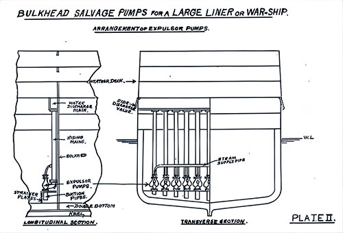
Plate 2: Diagram of the Bulkhead Salvage Pumps for a Large Liner or War Ship. Arrangement of Expulsor Pumps. Longitudinal Secion on Left; Transverse Section shown on Right. How to Save a Big Ship from Sinking (1915) p. 25. | GGA Image ID # 10e9d45a81
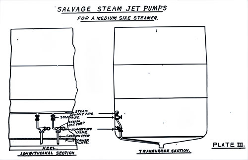
Plate 3: Diagram of the Salvage Steam Jet Pumps for a Medium Size Steamer. Longitudinal Secion on Left; Transverse Section shown on Right. How to Save a Big Ship from Sinking (1915) p. 26. | GGA Image ID # 10e9efc425
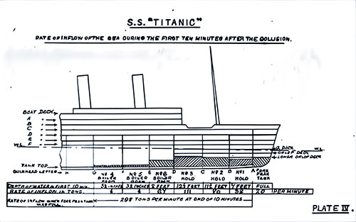
SS Titanic: Diagram of the Rate of Inflow of the Sea During the First Ten Minutes After the Collision. How to Save a Big Ship from Sinking (1915) p. 37. | GGA Image ID # 10a2d67377
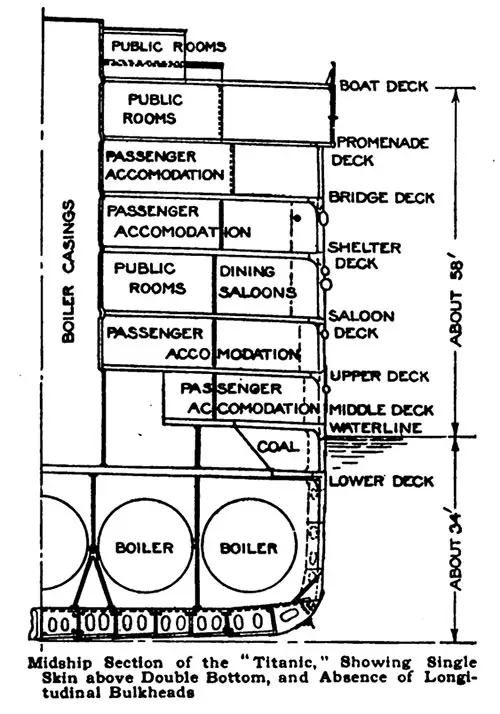
Diagram of the Midship Section of the "Titanic," Showing Single Skin above Double Bottom, and Absence of Longitudinal Bulkheads. Popular Mechanics Magazine (June 1912) p. 804-a. | GGA Image ID # 10819412ed
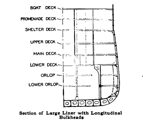
Diagram of a Section of Large Liner with Longitudinal Bulkheads. Popular Mechanics Magazine (June 1912) p. 804-b. | GGA Image ID # 1081fb580b
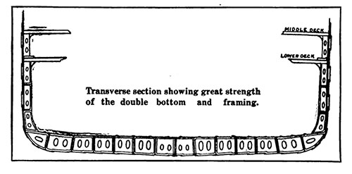
Transverse Section Showing Great Strength of the Double Bottom and Framing. Scientific American (27 April 1912) p. 381a. | GGA Image ID # 10a4a1ce59
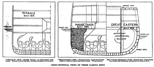
Cross-Sectional Views of Three Famous Ships. Titanic 1912.—Double bottom; no longitudinal bulkheads. Boilers clear across ship, bunkers arranged athwartship. Mauretania, 1907—Double bottom; Longitudinal bulkheads in wake of engine and boiler rooms. Wing bunkers. The "Great Eastern" 1858—Double shell: longitudinal and transverse bulkheads, all carried to topmost deck. Scientific American (11 May 1912) p. 417a. | GGA Image ID # 10a56bf6a3
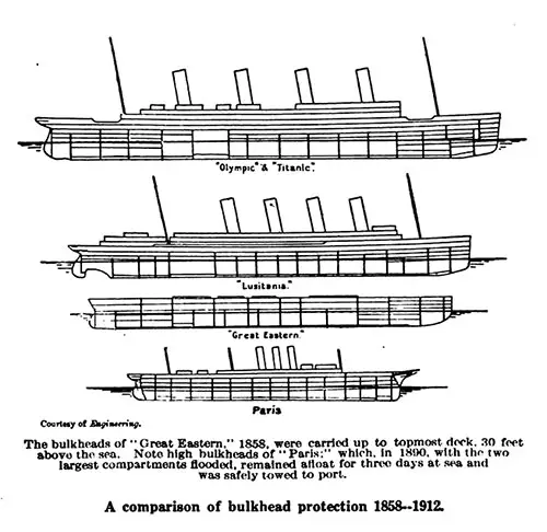
A Comparison of Bulkhead Protection 1858-1912: Olympic & Titanic, Lusitania, Great Eastern, and Paris. The bulkheads of " Great Eastern." 1858, were carried up to the topmost deck, 30 feet above the sea. Note high bulkheads of " Paris:" which, in 1890, with the two largest compartments flooded, remained afloat for three days at sea and was safely towed to port. © Engineering Magazine. Scientific American (11 May 1912) p. 418a. | GGA Image ID # 10a5c0fdd3
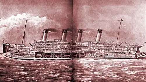
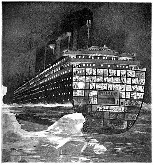
The Ill-Fated Titanic, Which Now Lies Under Two Miles of Water Between Sable Island and Cape Race: The Biggest Ship in the World Shown in Section. Drawn by W. B. Robinson, by Courtesy of the White Star Line. The Illustrated London News (4 May 1912) p. 654-655. | GGA Image ID # 1062b66a2e
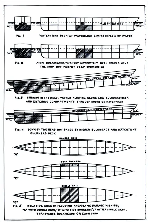
Diagram of Protective Value of the Bulkheads. The Unsinkable Titanic (1912) p,. 57. | GGA Image ID # 10764c1502
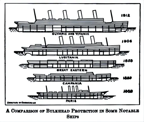
A Comparison of Bulkhead Protection in Some Notable Ships: Olympic and Titanic, Lusitania, Great Eastern, Campania, and Paris. The Unsinkable Titanic (1912) p,. 66. | GGA Image ID # 1077aea24f
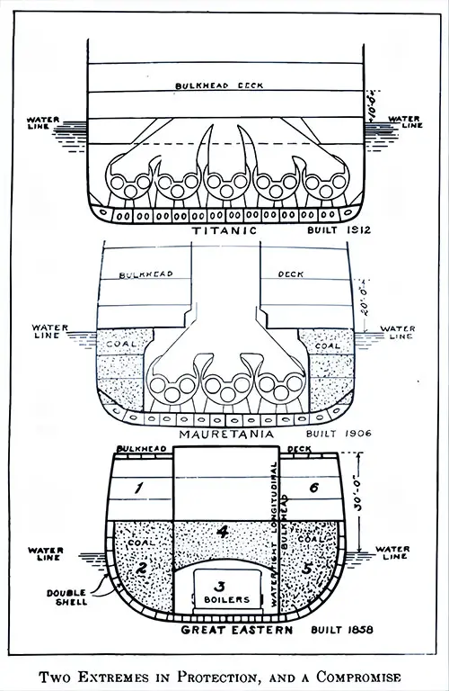
Diagram of Two Extremes in Protection, and a Compromise, showing the Titanic, Mauretania, and the Great Eastern. The Unsinkable Titanic (1912) p,. 83. | GGA Image ID # 1078954479
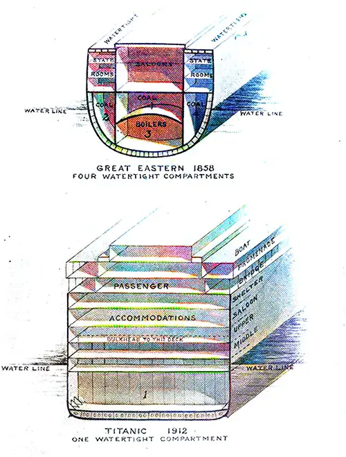
50-Years of a Decline in Safety of Construction in Ocean Liners. Watertight Compartments of The Great Eastern Compared to the Titanic. The Unsinkable Titanic (1912) p,. 93. | GGA Image ID # 1079683df4
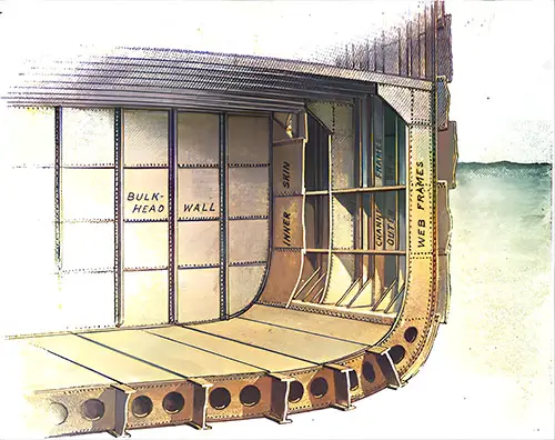
Plating Carried Up the Side Forms Inner Skin. The Unsinkable Titanic (1912) p,. 107. | GGA Image ID # 107a18e7ac
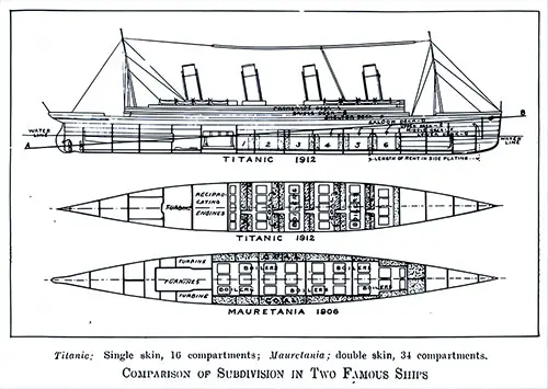
Comparison of Subdivision in Two Famous Ships. Titanic: Single Skin, 10 Compartments; Mauretania: Double Skin, 34 Compartments. The Unsinkable Titanic (1912) p. 130. | GGA Image ID # 107a917064
Why the Wound from the Iceberg Was Fatal. The official account of the disaster reads: "Struck berg bluff starboard bow, slight jar, but grinding sound, evidently opening several compartments starboard side." Had the 2-inch steel bulkheads withstood the water pressure the ship would not have foundered. The World To-Day (June 1912) p. 2376k. | GGA Image ID # 10972e2b1b
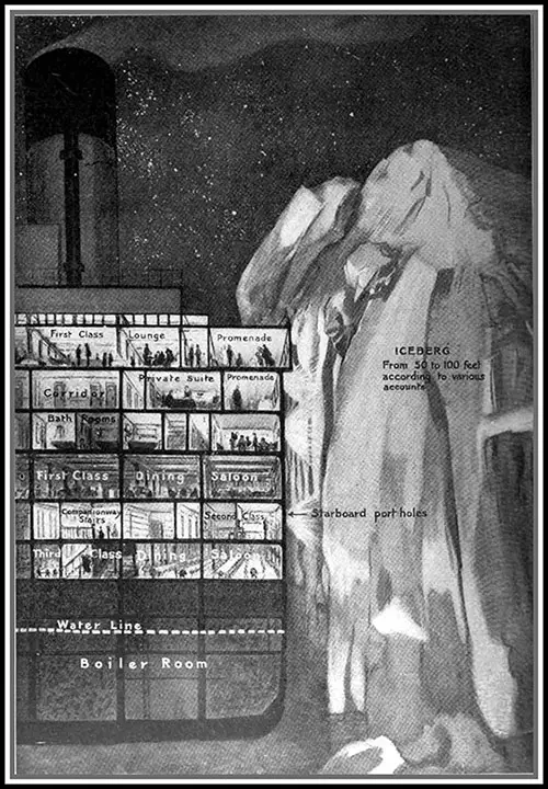
The Titanic Scraping Past the Iceberg. The iceberg was from fifty to one hundred feet high according to various accounts. Passengers in cabins and in smoking rooms report that after the slight jar, they saw the high iceberg go by close to the side of the boat. The World To-Day (June 1912) p. 2376l. | GGA Image ID # 109732742f
Five Stories Above the Sea. Seventy-five feet from the boat-deck to the sea-level as high as the fifth story of an office building. Imagine a wild sea, instead of the calm at the time of the Titanic catastrophe — and a swinging boat containing fifty or sixty persons, battering the ship’s side with every heave of the waters. The World To-Day (June 1912) p. 2376o. | GGA Image ID # 109784058e

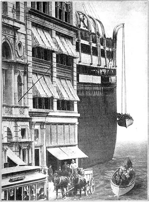
Surpassing the Greatest Buildings and Memorials of Earth. The Largest and Finest Steamers in the World White Star Line's New Leviathans "OLYMPIC" and "TITANIC" - 882 1/2 Feet Long 92 1/2 Feet Broad 45,000 Tons. White Star Line Brochure Olympic & Titanic (1911) p. 4. | GGA Image ID # 10a8d0071d
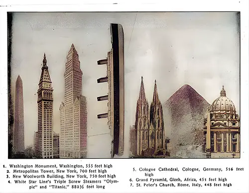
Length of Titanic Compared to Skyscrapers. Wreck and Sinking of the Titanic (1912) p. 112. | GGA Image ID # 108d2a1598
- Washington Monument, Washington, 555 feet high
- Metropolitan Tower, New York, 700 feet high
- New Woolworth Building, New York, 750 feet high
- White Star Line's Triple Screw Steamers "Olympic" and "Titanic," 882 1/2 feet long
- Cologne Cathedral, Cologne, Germany, 516 feet high
- Grand Pyramid, Gizeh, Africa, 451 feet high
- St. Peter's Church, Rome, Italy, 448 feet high
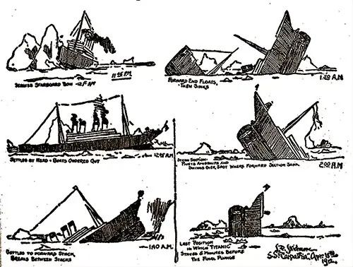
The Sinking of the Titanic. A Sequence of Sketches by Jack Thayer, a first-class passenger, and a survivor of the Titanic disaster. The then 17-year-old survived the sinking hanging on to the overturned Collapsible Lifeboat B later being picked up by Lifeboat 12. Jack, along with Harold Bride, Colonel Archibald Gracie, Charles Lightoller, and the chief baker, Charles Joughin managed to balance on the overturned boat for some hours before he was picked up. He was the only survivor to indicate that the ship broke into two pieces before sinking, his version, sketched out by him on 15 April 1912, confirmed by oceanographer Dr. Robert Ballard in 1985. Public Domain Image. | GGA Image ID # 10ef01cc8a
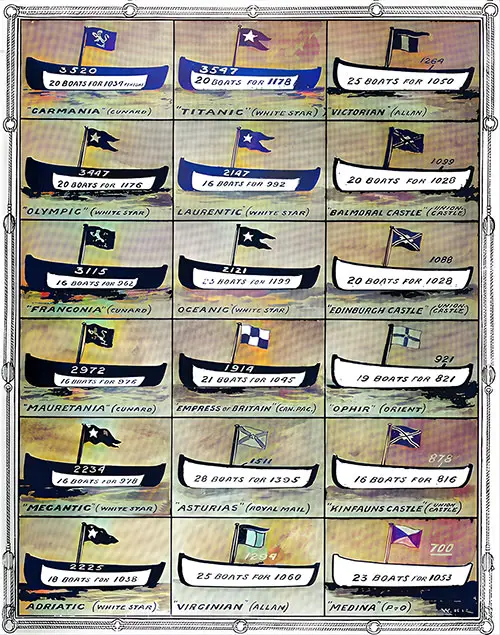
Liners and Their Life-Saving Craft before the Disaster: White Boats to Represent the Number of Persons for Whom Boats Were Carried; Black to Represent the Boats Required for the Ships' Full Complements. The Illustrated London News (11 May 1912) p. 689. | GGA Image ID # 100814f3ab
Graphs
A graph is a common data structure that consists of a finite set of nodes (or vertices) and a set of edges connecting them. A pair (x,y) is referred to as an edge, which communicates that the x vertex connects to the y vertex. In the examples below, circles represent vertices, while lines represent edges.
Results of the Titanic Disaster Analyzed. from Official Figures Given in the House of Commons. The Black Indicates Passengers and Crew Lost, and the White Indicates the Saved. © The London Sphere. The Literary Digest (25 May 1912) p. 1092. | GGA Image ID # 1086c6ddfa

The Loss of the Titanic. Results Analyzed and Shown in a Special Sphere Diagram Drawn from the Official Figures Given in the House of Commons. The Sphere, 4 May 1912. | GGA Image ID # 1101df2398
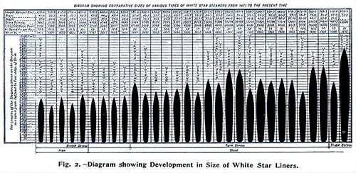
Fig. 2: Diagram Showing Development in Size of White Star Liners. Diagram Showing Comparative Sizes of Various Types of White Star Steamers From 1871 to the Present Time. The Lengths of the Shown on the Diagram are Taken from Taffrail to Fore-Edge of Stem. Ships illustrated (l to r): Oceanic-Baltic-Republic (1871), Tropic-Asiatic (1871), Adriatic-Celtic1872), Belgic-Gaelic (1873), Britannic-Germanic (1874), Arabic-Coptic (1881), Ionic-Doric (1883), Belgic-Gaelic (1885), Cufic-Runic (1888), Teutonic-Majestic (1889), Nomadic-Tauric (1891), Bovic (1892), Gothic (1893), Cevic (1893), Georgic (1895), Delphic (1897), Cymric (1898), Afric-Medic-Persic-Runic-Suevic (1899), Oceanic (1899), Celtic-Cedric (1901), Athenic-Corinthic-Ionic (1901), Arabic (1903), Romanic (1903), Cretic (1903), Canopic (1903), Cufic-Tropic (1904), Baltic (1904), Adriatic (1907), Laurentic (1909), Olympic-Titanic (1910). The Shipbuilder (Midsummer 1911) p. 5. | GGA Image ID # 10b1f5601e
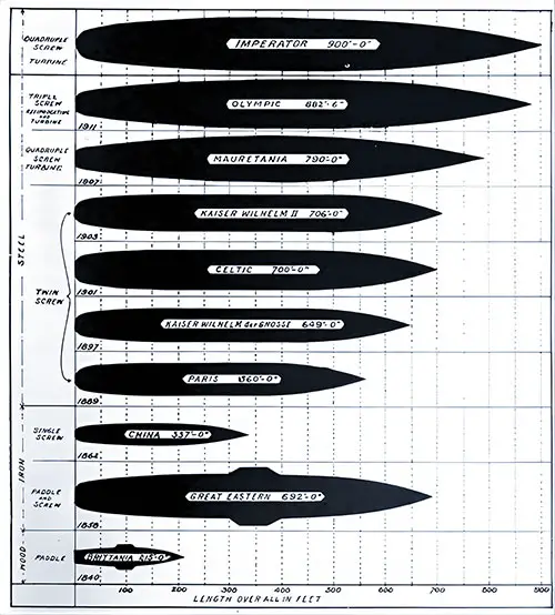
Growth of Transatlantic Steamships, 1840-1912. The Unsinkable Titanic (1912) p,. 7. | GGA Image ID # 1073fde953
Maps
A map is a symbolic representation of selected characteristics of a place, usually drawn on a flat surface. Maps present information about the world in a simple, visual way. They teach about the world by showing sizes and shapes of countries, locations of features, and distances between places.
Track Chart Showing the Place Where Titanic Struck an Iceberg and Sank at 2.20 A. M., April 15, 1912. American Medicine (May 1912) p. 273. | GGA Image ID # 105ea28490
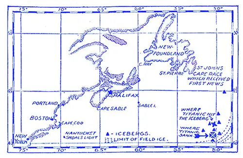
Map of the Perilous Ice-Covered Tract Where the Titanic Met Her Fate. Harper's Weekly (20 April 1912) p. 30. | GGA Image ID # 109a8a80c5
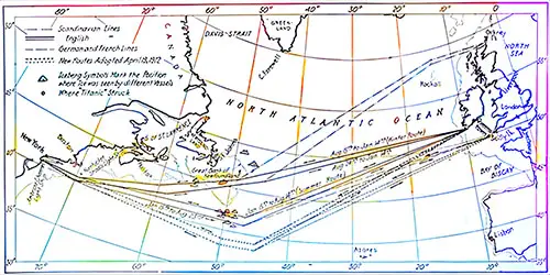
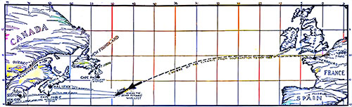
Chart of the North Atlantic, Showing the New Summer Routes for Steamers. The Turning Points are Indicated by Small Open Circles. Prepared from information furnished by hydrographic office by Engineering News. Marine News (May 1912) p. 158. | GGA Image ID # 10acd7665b
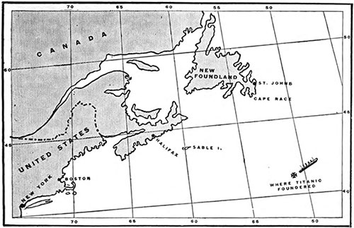
Map Marking the Location Where the RMS Titanic Foundered. The Titanic sank in 41.46 degrees N. latitude ; 50.14 degrees W. longitude. The distance from that point to Boston is 956 miles ; to Sandy Hook, New Jersey, the distance is 1.083 miles. From Halifax the distance to the spot is 610 miles, and to St. John's, Newfoundland, it is 362 miles. The Outlook (27 April 1912) p. 877. | GGA Image ID # 10e6d62af4
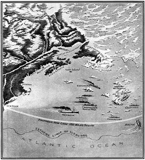
The RMS Titanic, When It Sank, Was in 41° 46 Min. N. Lat., 50° 14 Min. W. Long., Approximately the Same Latitude as New York and Madrid. The Distances of Other Vessels in the Vicinity from the Ill-Fated Ship at the Time She First Flashed Distress Signals Were: SS California, about 10 Miles; SS Mt. Temple, 20 Miles; SS Frankfort, 40 Miles; SS Carpathia, 58 Miles: SS Niagara, 75 Miles: SS Virginian, 120 Miles; SS Baltic, 100 Miles; And SS Olympic, about 250 Miles. Popular Mechanics Magazine (June 1912) p. 799. | GGA Image ID # 1080c2bc2d
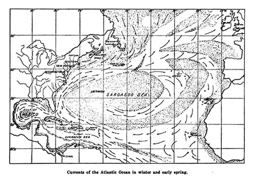
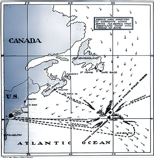
Currents of the Atlantic Ocean in Winter and Early Spring. Scientific American (27 April 1912) p. 377b. | GGA Image ID # 10a37f032d
Map Showing Where The RMS Titanic Sank on 15 April 1912. (The broken lines indicate how the other steamers answered the wireless calls for help). The American Review of Reviews (May 1912) p. 551. © New York Times. | GGA Image ID # 105425a1c3
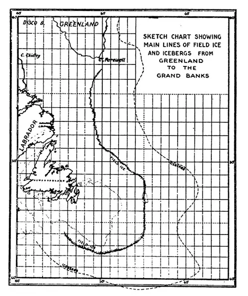
Sketch Chart Showing Main Lines of Field Ice and Icebergs from Greenland to the Grand Banks. The Independent (25 April 1912). p. 872. | GGA Image ID # 10a12c3921
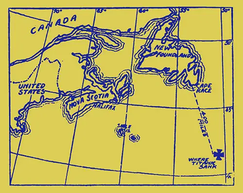
Map Showing the Location Where the RMS Titanic Sank. The Literary Digest (27 April 1912) p. 867. | GGA Image ID # 1084cab48c
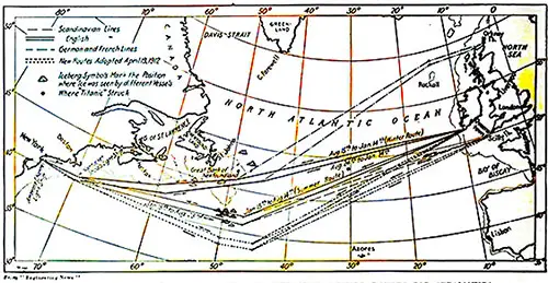
Chart of the North Atlantic Showing the New Summer Routes for Steamships. Inter Routes of German and French Lines Are Not Shown. the Turning Points Are the Same as for the English Lines. These Points Are Indicated by Small Open Circles. Position of Icebergs Is Shown by Shaded Spots. © Engineering News. The Literary Digest (11 May 1912) p. 982. | GGA Image ID # 1086b494ee
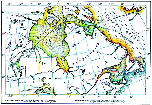
A Route That Will Defy The Icebergs. The Proposed Hudson Bay Route to Europe. Dotted with Bcrgs and Shrouded in Fog. © Engineering News. The Literary Digest (25 May 1912) p. 1097. | GGA Image ID # 10881b7ac3

The Danger Field of the Atlantic--How the Steamer Routes Cut Through Fog and Ice. The Sphere, 4 May 1912. | GGA Image ID # 110231a14c

Ships That Might Have Rescued Everyone on the Titanic if Events Had Only Been Slightly Different. The Sphere, 4 May 1912. | GGA Image ID # 11027abdcb
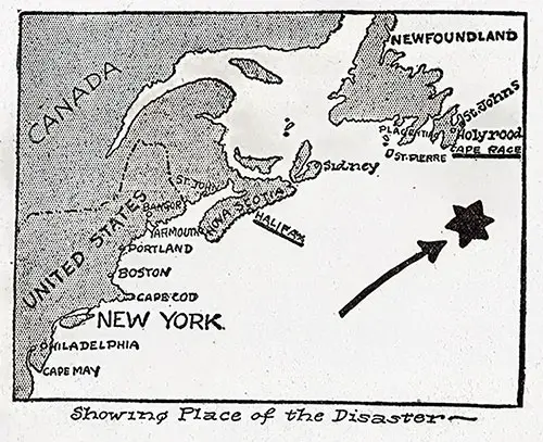
Map Showing Place of Disaster. Wreck and Sinking of the Titanic (1912) p. 106. | GGA Image ID # 108c85c368
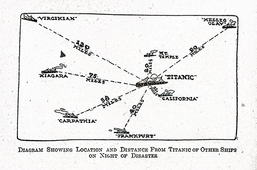
Diagram Showing Location and Distance from Titanic of Other Ships on Night of Disaster. Wreck and Sinking of the Titanic (1912) p. 206. | GGA Image ID # 10904cdd64

Chart No. 2, Titanic, 1912 Presented as Evidence at the Hearing, This Chart Shows the Positions of Ice and Other Ships in the Vicinity of the Titanic the Night It Sank. Hearings before a Subcommittee of the Committee on Commerce, United States Senate, Sixty-Second Congress, Second Session, under S. Res. 283 Directing the Committee on Commerce to Investigate the Causes Leading to the Wreck of the White Star Liner "Titanic." National Archives and Records Administration, Washington, D.C., 1912. | GGA Image ID # 1be736042b

How the Titanic Met with Disaster on Her Maiden Voyage. The Titanic Sailed from Southampton on Wednesday, April 10TH, and She Struck the Iceberg on Sunday, April 14TH, at 10.25 P.M. (American Time), in the Neighborhood of the Newfoundland Banks to the South of Cape Race. After the Collision, the Titanic Sent Out Wireless Appeals for Immediate Assistance, Which Were Recorded on the Virginian, the Baltic, the Carpathia, and Her Dater Ship, the Olympic. All These Vessels Proceeded at Once to the Disaster Scene, but Apparently, Only the Carpathia Was in Time to Render Assistance. The Diagram Illustrates the Position of the Titanic at the Time of the Catastrophe and Shows the Locality of the First Boats to Receive the Distress Signals. Inset Portraits (Left): Lord Pirrie, Chairman of Messrs. Harland and Wolff, the Builders of the Titanic; (Right) Captain Smith, the Commander of the Titanic, Who Went Down with the Ship. | GGA Image ID # 1be7360e6c
Key Highlights and Most Engaging Content
1️⃣ Passenger Survival Rates by Age and Class 👶👵🚢
🔹 A series of graphic charts break down passengers, survivors, and victims by age groups (0-12, 13-17, 18-24, etc.).
🔹 These visuals reveal stark differences in survival rates based on age and class, highlighting the disparities in access to lifeboats.
🔹 First-Class children had higher survival rates, while older passengers, particularly in Third Class, faced grim odds.
🔹 Noteworthy Image: Graphic Chart of Titanic Passengers, Survivors, and Victims (by Age Group)
📌 Significance: These charts humanize the statistics, illustrating how survival chances changed based on social class and vulnerability.
2️⃣ The Titanic’s Watertight Compartments: Engineering Strength or Fatal Flaw? ⚙️⚠️
🔹 Tables detail the layout and function of Titanic’s watertight compartments, showing how they were designed to contain flooding.
🔹 The bulkheads’ placement and height limitations contributed to the ship's rapid sinking, as water spilled from one compartment to another.
🔹 A comparison table examines how Titanic’s bulkhead design stacked up against other notable ships, such as the Lusitania and Great Eastern.
🔹 Noteworthy Image: Table of Titanic’s Watertight Compartments
📌 Significance: Essential for understanding why the ship was initially considered “unsinkable” and how its design ultimately failed.
3️⃣ Lifeboat Capacity vs. Passengers on Board 🚣♀️👥
🔹 A startling table reveals the insufficient number of lifeboats on transatlantic liners before the Titanic disaster.
🔹 It compares popular passenger ships, their total capacity, and how many people could actually fit in lifeboats.
🔹 Titanic’s lifeboat shortage was not unique—it was an industry-wide issue, making the tragedy a wake-up call for maritime safety reforms.
🔹 Noteworthy Image: Table Showing Popular Steamships and Lifeboat Capacity
📌 Significance: Highlights the regulatory negligence that left thousands of lives at risk on ocean liners of the era.
4️⃣ The Titanic’s Final Moments: Structural Diagrams & Water Inflow 🌊🕰️
🔹 A detailed diagram illustrates how water flooded the ship within the first ten minutes of the iceberg collision.
🔹 Cross-sectional diagrams compare Titanic’s single-skin hull with double-bottom designs used in other ships.
🔹 The official accounts of Titanic’s sinking show why the ship broke apart due to structural stress before submerging.
🔹 Noteworthy Image: Diagram of Titanic at 2:15 AM (Sinking Sequence)
📌 Significance: Offers a step-by-step breakdown of how and why Titanic broke in two—valuable for forensic and engineering studies.
5️⃣ Comparing Titanic to Other Great Ships 🚢📏
🔹 Graphs and tables compare Titanic’s size, tonnage, and speed with famous ocean liners like the Mauretania, Lusitania, and Great Eastern.
🔹 One diagram maps the steady growth of transatlantic steamships from 1840 to 1912, showing Titanic as the culmination of decades of innovation.
🔹 Another table compares bulkhead spacing, subdivision, and hull integrity among different liners.
🔹 Noteworthy Image: Growth of Transatlantic Steamships (1840-1912)
📌 Significance: Demonstrates how Titanic represented both progress and shortcomings in ship design.
6️⃣ The Disaster’s Geographic Context: Maps & Iceberg Routes 🗺️🧊
🔹 A variety of maps pinpoint Titanic’s location at the moment of impact and during rescue efforts.
🔹 Some track the movement of icebergs in the North Atlantic, showing how Titanic was caught in a deadly field of ice.
🔹 Another map compares Titanic’s final position to other nearby vessels, raising questions about why some ships failed to respond in time.
🔹 Noteworthy Image: Map of Iceberg Paths and Titanic’s Route
📌 Significance: Essential for understanding why the collision occurred despite warnings and how icebergs were a known hazard in transatlantic travel.
Relevance for Teachers, Students, Historians, and Genealogists
👩🏫 Teachers & Students:
🔹 Provides primary source material for research papers on social class survival rates, ship engineering, or maritime safety regulations.
🔹 Encourages data analysis and historical inquiry, using graphs and charts to draw conclusions about the tragedy.
📜 Historians & Maritime Enthusiasts:
🔹 Helps contextualize Titanic’s place in maritime history, technological advancements, and safety failures.
🔹 Provides direct visual comparisons with other ships, making Titanic’s shortcomings and achievements clearer.
🧬 Genealogists & Family Historians:
🔹 The passenger survival charts by age and class help descendants trace family members’ experiences.
🔹 Lifeboat capacity and survival tables offer clues about how different groups fared in the evacuation.
Encouragement for Students: Essay & Research Topics
💡 Need Essay Ideas?
🔹 How did age and social class affect survival rates on the Titanic?
🔹 Why was Titanic’s lifeboat capacity inadequate, and how did this compare to other ships?
🔹 What do maps and charts reveal about the iceberg collision and rescue efforts?
🔹 How did Titanic’s design compare to other great ships of its time?
🚢 Titanic’s story isn’t just about the people—it’s about the numbers, the science, and the decisions that shaped history. 📊📖