
The Port of Antwerp – Historic European Maritime Hub

Table of Contents
- Introduction
- Geographic Advantages of Antwerp
- Historical Development of the Port
- Antwerp Before World War I
- Impact of World War I and Postwar Recovery
- Port Infrastructure and Facilities
- Commerce and Trade Patterns
- Emigration Through Antwerp
- Expansion Plans and Engineering Projects
- Notable Statistics and Tables
- Historic Images and Maps
- Bibliography and Source Credits
Introduction
The Port of Antwerp page on the GG Archives is an exceptionally rich, detailed exploration of one of Europe’s most important maritime hubs. It offers tremendous value to teachers, students, genealogists, historians, and collectors seeking to understand the social, economic, and logistical networks that defined ocean travel from the late 19th through early 20th centuries.
Geographic Advantages of Antwerp
Antwerp harbor is unique, lying about fifty miles from the North Sea, on the right bank of the river Scheldt, at the crossing of the most important maritime route and the densest and most extensive net of rivers, canals and railroads.
Historical Development of the Port
Early Origins and Name
Legend holds that Antwerp got its name from the giant Antigone who demanded tolls from passing ships and cut off the hands of those who refused to pay, throwing them into the Scheldt. The hero Brabo slew him, severed his hand, and flung it into the river. Thus “Antwerpen” means “hand throwing.”
Medieval Decline and Revival
During the 16th century Antwerp was one of Europe's wealthiest ports, dealing in spices, textiles, and colonial goods. Its decline came with the closure of the Scheldt by the Dutch under the Treaty of Westphalia. It revived under French rule in the late 18th century, with the Scheldt reopened to navigation in 1792.
19th-Century Expansion
In 1863, the Dutch toll was bought out for $9 million, enabling Antwerp to develop into a leading European port. The river quays were constructed, docks were expanded, and rail links connected it to the industrial centers of Belgium, France, Germany, and beyond.
Antwerp Before World War I
By the early 20th century, Antwerp rivaled Hamburg and Rotterdam as the leading port of Northern Europe. It was a critical transit point for goods flowing between industrial Germany and overseas markets. Antwerp handled millions of tons of imports and exports, including grain, textiles, coal, and manufactured goods.

View of the Grand Basin at Antwerp. Ports of the World (1912). | GGA Image ID # 2287943ec6
Impact of World War I and Postwar Recovery
Despite the German occupation, Antwerp’s port facilities were not destroyed but clogged with war material. After the armistice, Belgian authorities cleared 700,000 square meters of timber, sand, and gravel from the docks. By mid-1919, normal operations resumed, and massive projects were restarted to expand capacity for the postwar boom.

Large Floating Pontoon at the Port of Antwerp, Belgium circa 1909. Ports of the World, 1909. | GGA Image ID # 22886d8e15
Port Infrastructure and Facilities
The Port of Antwerp was (and remains) one of the most technically advanced European ports of its era.
River Quays
Nearly four miles of quay walls equipped with sheds, cranes, and broad roadways allowed ocean-going ships of great draught to moor directly without lightering.
Maritime and Barge Docks
Twenty docks, including 16 maritime and 4 barge docks, were connected by locks to maintain water levels regardless of tides. They offered 15 miles of quayage.
Dry Docks
Antwerp boasted 7 dry docks in the early 20th century, including massive new ones capable of handling the largest ocean liners.
Cranes and Elevators
Over 300 hydraulic and electric cranes (2–2.5 tons capacity each), plus specialized 20, 40, and even 120-ton cranes, handled heavy cargo. Pneumatic grain elevators and coal-tipping devices supported bulk trade.
Rail and Canal Connections
An extensive network of 156 km of rail lines and numerous canals connected the port to Belgium’s industrial centers and the broader European hinterland.

Red Star Liner SS Gothland Entering Rovers Sluice at Antwerp Harbor. Shipping Magazine (25 November 1921) | GGA Image ID # 228877d0b2
Commerce and Trade Patterns
Antwerp’s port handled a vast range of goods: grain from Russia and America, coal and coke from Germany, petroleum, textiles, machinery, and colonial produce. It served as the natural maritime gateway for industrial Germany as well as Northern France, Switzerland, and even Austria.
Regular steamship services connected Antwerp with New York, Montreal, South America, South Africa, India, and the Far East. Major shipping lines included the Red Star Line, which carried countless emigrants to North America.
Emigration Through Antwerp
Antwerp was a crucial port of embarkation for European emigrants in the late 19th and early 20th centuries, second only to Hamburg and Bremen in Germany. For many Eastern Europeans—especially Jews fleeing pogroms—Antwerp was an essential escape route to America and Canada.
Steamship companies, particularly the Red Star Line, maintained dedicated facilities for emigrants, including lodging houses, medical inspections, and processing centers designed to meet international health regulations and reduce quarantine risks at the destination.

Kattendyk Dock at Antwerp Harbour. Ports of the World (1912) | GGA Image ID # 22888f0e35
Expansion Plans and Engineering Projects
Following World War I, Antwerp undertook massive modernization and expansion projects to remain competitive with Hamburg, Rotterdam, and London. This included:
- Construction of new docks in the North Dock system
- Expansion of quay walls
- New dry docks and repair facilities
- Installation of state-of-the-art cargo-handling equipment
Engineering works were designed to allow larger ships to dock and to speed up the loading and unloading processes. Belgian authorities invested heavily in modernization to maintain Antwerp’s status as a leading European port.
Notable Statistics and Tables
Below is a table showing some historic statistics for the Port of Antwerp before World War I:
The following table gives the dimensions of the Antwerp Docks :
| Name of Dock | Length (Ft) | Width (Ft) | Surface acres |
|---|---|---|---|
| Bonaparte Dock | 492 | 558 | 6.3 |
| Guillaume Dock | 1,246 | 492 | 14.4 |
| Junction on Kattendyk Dock | 279 | 164 | 1.1 |
| Kattendyk Dock | 3,149 | 459 | 33.3 |
| Kattendyk Lock Chamber | 361 | 230 | 1.8 |
| Timber Dock | 1,706 | 492 | 19.2 |
| Campine Dock | 1,148 | 525 | 13.8 |
| Asia Dock | 2,001 | 328 | 15.1 |
| Junction on Lefebvre Dock | 377 | 164 | 1.4 |
| Lefebvre Dock | — | — | 31.8 |
| American Dock | — | — | 16.6 |
| Basin Dock | 2,050 | 820 | 38.6 |
| Wet Dock, North | 1,722 | 590 | 24.0 |
The various schemes will take ten years to execute, and the following table will afford some figures for comparison :
| Present day Situation | Sit. about 1920, after the various works described above have been executed. | |
|---|---|---|
| Surface of Docks | 230 acres | 1,260 acres |
| Length of Quaywalls and Slopes | 9.94 miles | 31 miles |
| Area of Sheds | 141 acres | 840 acres |
A shifting station, vast in extent, on the present territory of Merxem is in full course of construction. A large boulevard winding around the new maritime installations will shortly be laid down, and also a "Transporder" bridge, connecting the two banks of the Scheldt, will be constructed over the up-stream.
Historic Images and Maps
Below are selected images and maps showcasing the port’s facilities, docks, and maritime activity:

Open Sheds on the Scheldt River Quays at Antwerp. Report of the Connecticut River and Harbor Commission (1910) | GGA Image ID # 2288d86f70

South Promenade of the Scheldt River Quays. Furnishing a Splendid View of Shipping Activities on the River Scheldt. Goods Pass to and From the Ships and Open Sheds Underneath the Promenade. Report of the Connecticut River and Harbor Commission (1910) | GGA Image ID # 2289399811
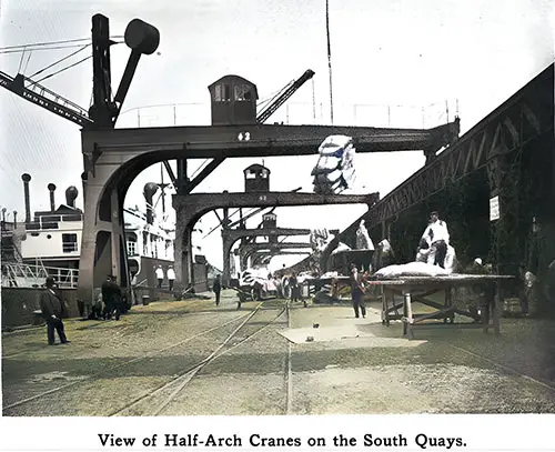
View of Half Arch Cranes on the South Quays at Antwerp. Report of the Connecticut River and Harbor Commission (1910) | GGA Image ID # 22893b3209

Fifty-Ton Electric Hoisting Crane on the South Quays at Antwerp. Report of the Connecticut River and Harbor Commission (1910) | GGA Image ID # 228959a8a6

Cranes on the Campine Dock at Antwerp. Report of the Connecticut River and Harbor Commission (1910) | GGA Image ID # 2289ac813c

Belgium Government Bonded Warehouse at Antwerp. Report of the Connecticut River and Harbor Commission (1910) | GGA Image ID # 2289c1ea21

Map of the Scheldt from Antwerp to the Sea. Dr Norddeutsche Lloyd, 1892. | GGA Image ID # 21604a4562. Click to View Larger Image.

Present Dock System of Antwerp shown in black near C. Present course of River Scheldt A, B, C, D. Proposed "Grande Coupure" (great cut) in river channel A, E, C. Proposed great extension of dock system shown to the right of new river channel C, E, A. Ports of the World (1909) | GGA Image ID # 2289c91c70. Click to View a Larger Image.
Bibliography and Source Credits
Sources for this detailed port history include The Nautical Gazette, Shipping Publishing Co., and period travel guides. These contemporary accounts provide rich, first-hand perspectives on the port’s operations, expansion, and role in world trade.
Bibliography
"Port of Antwerp: Growth of the Port" in Shipping: Marine Transportation, Construction, Equipment and Supplies, New York: Shipping Publishing Co, Volume 15, No. 5, March 10, 1922 P. 40-41.
"Port of Antwerp - Progress of Overseas Traffic" in Shipping: Marine Transportation, Construction, Equipment and Supplies, New York: Shipping Publishing Co, Volume 15, No. 1, January 10, 1922 p. 43.
L. W. Alwyn-Schmidt, “Antwerp’s Pre-War and Future Status.” In The Nautical Gazette, Volume 95, No. 16, Whole No. 2488, Saturday, 19 April 1919, Page 268.
“From Correspondents: Antwerp’s Quick Revival.” The Nautical Gazette: An International Weekly Newspaper of Shipbuilding, Shipping, Marine Insurance and Export News, Volume 95, No. 15, Saturday, APRIL 12, 1919, P. 258.
“Antwerp’s Port in Good Shape.” In The Nautical Gazette, Volume 95, No. 13, March 29, 1919, Page 214.
"Antwerp's Past, Present and Future." In The Nautical Gazette, 1 February 1919.
"The Port of Antwerp. An overview of the Harbor and City" Courtesy of Leo Van Riel, Manager of the Municipal Information Office at Antwerp. circa 1913.
Presbrey, Frank, "Approach to Antwerp," in Presbrey's Information Guide for Transatlantic Travelers, Seventh Edition, New York: Frank Presbrey Co., 1911: P. 46.
Frederick L. Ford "The Port of Antwerp," in "Part II. A Study of Some Representative European Ports in the Summer of 1909", in the Report of Connecticut Rivers and Harbors Commission to the General Assembly, Hartford: State of Connecticut, 1911, p.48-52.
🌟 Relevance to Ocean Travel Research
⚓ For Teachers & Students
A rich case study of European port development, trade infrastructure, and emigration patterns. Excellent for lessons on industrialization, globalization, and migration history.
✅ Includes primary-source statistics and images for classroom use or essay citations.
🧭 For Genealogists
Antwerp was a major emigration gateway. This page explains shipping lines’ role in immigrant processing, health checks, and departure documentation. It’s essential for understanding ancestors’ journeys.
📚 For Historians
Detailed views on pre- and post-WWI geopolitics, economic rivalries among Rotterdam, Hamburg, and Antwerp, and shipping companies’ commercial strategies.
🗂️ For Collectors & Maritime Enthusiasts
Fascinating technical details on docks, cranes, locks, dry docks, and expansion projects. Rich imagery documents industrial port life in the early 20th century.
✨ Most Engaging Content Highlights
✅ The Port’s Strategic Geography
"Antwerp harbor is unique, lying about fifty miles from the North Sea, on the right bank of the river Scheldt..."
👉 Excellent for illustrating how inland ports leveraged river systems for ocean access.
✅ Red Star Line’s Role
Detailed treatment of emigrant traffic management, medical checks, and cooperation with German shipping companies pre-WWI.
✅ Post-WWI Recovery
"Three months ago, anyone visiting it would have concluded that at least half a year must elapse before its trading and shipping activities could possibly be resumed..."
👉 Vivid primary-source account of Antwerp’s rapid restoration after German occupation.
✅ Economic Competition
Insightful analysis of Rotterdam’s rivalry and the infrastructure race that shaped European trade.
✅ Future Planning & Grand Engineering
Massive dock expansions, new locks, modern cranes—showcasing the scale of early 20th-century maritime engineering.
✅ Immigration History
Explains Antwerp’s critical role for genealogical research, detailing emigrant flows and steamship agreements.
✅ Historical Context
Includes the cultural legend of Antwerp’s name (Ant + Werpen) and its centuries-long evolution as a port city.
📸 Noteworthy Images (with Suggested Highlights)
- 🖼️ Red Star Liner Gothland Entering Rovers Sluice (c.1921): Shows migration-era shipping infrastructure.
- 🖼️ Sketch Map of Belgium with Railroads: Perfect for showing Antwerp’s hinterland connections.
- 🖼️ Landing Stage at Antwerp: Evokes period passenger experience—excellent for teaching port logistics.
- 🖼️ View of Antwerp Harbor: Immersive period photography for analyzing urban-industrial seaports.
- 🖼️ Part of New North Docks – Grain Elevators at Work: Highlights technological modernization.
- 🖼️ Large Floating Pontoon like Liverpool’s Landing Stage: Good for comparative port design discussion.
- 🖼️ Map of the Scheldt from Antwerp to the Sea (1892): Explains river navigation challenges and advantages.
✅ Encouragement for Students
✏️ Students: Consider using these GG Archives materials in your essays or projects! Our primary-source excerpts, images, and data help bring writing to life with authentic period detail.